Sunday, September 21, 2008

The Cornwall (UK) Ride


I’ve been fortunate enough to have visited England a few times on business over the past couple years and each time I’m here, I think about how cool it would be to tour the countryside on a motorcycle. While I was planning my current visit, I did a search on motorcycle rentals in Cornwall and was pleased to find a place called Cornish Wheels in a town called Redruth. I sent an email with several questions to their info address and within a day or two I heard back from David, who runs the joint. He told me about the kinds of bikes they have, the cost (rental, insurance and gear), and what sort of documents he’d need for the rental.

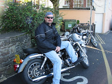
The weather was promising for the weekend so I went ahead and told David I’d be there at 9am on Saturday to pick up the bike. He opened up the shop and pulled out the bike I’d requested, a 2008 Triumph Bonneville America. I’d never ridden a Triumph before, but I’d heard good things about them. Besides, one should ride an English bike when in England, right? He also loaned me a great Harris riding coat, gloves, and a helmet. I would’ve loved to have had my own helmet since the “Large” helmets he had, weren’t. I really didn’t want to lug a helmet across the pond for one day of riding, but judging from the headache I had when I was done for the day, it probably would’ve been worth it.

We got the paperwork taken care of, David did an inspection on the bike and I got suited up for the ride. I told him that I was planning on heading down to Land’s End, so he suggested that I first head over toward St. Ives and head down the coastal highway. He said that the scenery was beautiful and that it was a great ride apart from the tourist traffic and farm vehicles during the summer. David gave me a couple pointers for riding in England, specifically Cornwall, where the hedgerows are walls of rock hidden by bushes. In some parts of the country a rider can possibly make an emergency ditch into a hedgerow. Not Cornwall. You’ll just bounce off the hedgerow and end up getting clobbered by the oncoming threat anyway.

David offered to have me follow him out to the A30, where I started my day of riding. He broke off and I proceeded south for a few miles getting use to the Triumph on a good road. Turing west on the A3074, I moved on into St. Ives. I cruised through town and took in the sights until coming to the B3306 where I turned south again and began to ride along the West Cornwall coastline. I really didn’t have any particular plan on this ride other than to follow my nose and keep the ocean on my right. I had to have the bike back at 6pm, so I had about eight hours to see what I could see.

I’d left the hotel before breakfast was served so by now I was starting to get hungry. Naturally, being in Cornwall, I started looking for somewhere that I could have a “proper” Cornish Cream Tea. This isn’t just tea with cream in it. A Cream Tea is a scone or two split horizontally and topped with fruit jam and a healthy splat of clotted cream (another Cornwall specialty). It’s usually served with a pot of tea as well. Not too far away from St. Ives, I came across Rosemergy Cream Teas. Rosemergy is a small holiday hamlet tucked in below the cliffs of West Cornwall and has a great view of the ocean only about a mile away. I stopped in and ordered a Cream Tea and took a seat outside to enjoy the sunshine and the view. Jane, the owner, gave me several suggestions of nearby places to see.

Heading back out on the B3306, I began to really enjoy the ride as I was getting use to the bike and the roads. The curves were awesome! One thing to keep in mind about “B” roads when riding a motorcycle; you won’t “B” in 5th gear very often, if ever! There weren’t any switchbacks since I wasn’t climbing any hills, but there are both sweeping and sharp curves as the road cuts through the hedgerows that have been there for centuries. Some places on the B3306 were wide enough for two cars to comfortably pass through. Other places aren’t quite so wide. There were several times when I had to stop and tuck up tight to the hedgerow to allow an oncoming car to pass without getting clocked by their mirror. Just about all of the Brit drivers that I’ve come across are very courteous, pulling over to allow you to pass and waving when somebody does that for them.

The Cornish coast is rugged and there are great little towns to ride through. Sennen Cove has a great beach where I saw a lot of surfers, and they also have a working harbor for various fishing boats to use. The view from Land’s End was great as well, but really, the only thing different about it was that it is the western-most point in the UK. There are several shops and café’s, and a sign that pointed to New York with a distance of 3147 miles away. I even had a little vision of home, too, when I saw a guy taking pictures with a Steelers shirt on!

Continuing along the coastline, I broke off of the B3306 to ride down a very tight lane to Lamorna Cove where I saw some divers coming out of the water. I snapped a couple pictures and got back out on the road and rode on into Penzance (as in “Pirates of”). The tide was out, so I took a couple pictures of all of the boats in the harbor sitting up on the mud. Riding on out to Marazion, I parked and walked out to St. Michael’s Mount, about 400 yards offshore. At low tide, you can walk out to the island on a causeway.

The castle was closed, so I went back to the bike and headed off again. Still keeping the water on my right I pushed on toward “The Lizard,” a peninsula in Cornwall which holds the most southern part of England. Lizard Point was a great place to park the bike and walk around. The scenery was spectacular with high rugged cliffs, a big lighthouse, and the western English Channel spread out in front of me.

Pictures taken, I had to start making my way back toward Redruth. Taking a northerly course, I rolled through several small towns and some great countryside. After stopping for a cup of tea (hey, when in England…) and getting a suggestion to visit the Truro Cathedral from a couple blokes in a pub, I headed that way. Truro is a great town and the Cathedral is indeed grand. It’s also relatively new, as far as European cathedrals go. The foundations stones were laid in 1880 and the Nave was dedicated in 1903. I was invited in for a quick look around by a gentleman coming in for their worship service which would be starting shortly.

I walked around town for a short time and took a couple more pictures, then it was time to head back to Redruth. A “petrol” stop set me back around $20, and I pulled back into Cornish Wheels at 6pm.

What a way to spend a day in England! I got to see a lot of beautiful countryside, speak with some locals, and get some serious riding in. The Triumph was a great bike; it's comfortable, easy to handle, and had plenty of power and speed when I needed it. It was probably the easiest-shifting bike I’d ever ridden, too. The brakes were superb, and they got a heavy workout on my ride. In fact, when I was sitting in church this morning I realized that my right forearm was a little sore – probably from all the brake squeezing I was doing on those great roads! The bike (with insurance) only set me back $183, within a few dollars of what I paid for the Electra Glide I rented in Branson this summer.

I had the bike for about eight hours, and I was probably on the road close to six and a half of those. You’d think those hours would pile up the miles, but you’d be wrong. When I pulled back into Cornish Wheels, I only had 118 miles on the trip counter. Even though I was underway for most of the day, I spent most of that time doing around 30 mph. That really indicates what kinds of roads they have in Cornwall; you just can’t open it up without seriously endangering your life. Sport bike riders would have a field day here if the roads were closed for a race, but flying around totally blind corners on roads that are barely single-lane size back in the states would probably not end well.

So if you’re ever in England, be sure and look into renting a bike for a day or two and check out this beautiful country while enjoying a ride that you won’t soon forget. If your trip takes you into Cornwall, look up David’s shop at www.cornishwheels.com.

Monday, September 1, 2008

The High Rock Ride

On Saturday, August 31st, a nice-sized group from the Bayside Believers took a ride up to the High Rock Overlook in Washington County, just south of the Mason-Dixon Line. I’d heard a lot about the view from this perch, as well as the fact that hang gliders use it for a launch site.

KarenSue and I pulled out on our bikes at about 8:45, planning to meet up with the rest of the gang in Clarksville around 9am. When we got to the meeting point in Clarksville, we found that Chuck Ridgely and Jeff & Angela Wightman were already there. We hung around chatting for a while before we noticed that it was nearing 9:30 and there was still no sign of the Glen Burnie contingent. Figuring that the folks who were late were all Harley riders, we thought there were probably mechanical issues that were keeping them delayed! A few minutes later we heard the hogs rumbling up to the light. Turns out, Road Captain Bill Cassell had confused Odenton with Clarksville. That’s easily understandable, right?

Joining us on the on-ramp to Rt. 32 were Bill and Gail Cassell, John and Patti Rogers, Bill and young Miss Gabby Coursey, Ronnie Kirkendall and Penny Holtz, and Jim Kemplin. Bill Cassell led us in prayer and we were on our way northwest toward Eldersburg.

Passing through Sykesville, I had my first near-miss of the day. I was bird bombed, and it hit about ½” below the top ridge of my windscreen. I know that many of us enjoy being closer to nature when we’re on our bikes but this was one part of nature I’m glad to have missed, however!

Once we got to Eldersburg, we turned left and headed west on Rt. 26 which really becomes a beautiful ride once you clear out of the sub-divisions west of Eldersburg. We rolled along until we came up to Libertytown when we turned right onto Rt. 550 toward Thurmont. KarenSue and I take this route whenever we ride up to Gettysburg and absolutely love it. The rolling hills, gentle curves and beautiful scenery are a great escape from the Baltimore – DC corridor. I know that we’re not supposed to covet what other people have, but I confess that I really love many of the homes that I see out in Carroll and Frederick counties!

The morning had been cool, damp, and heavily overcast but when we stopped for a quick potty break in Thurmont, the sun was poking through strong and several of us removed a layer of shirts. However, Bill advised that we were going to be heading up into the mountains and the temperature was going to be dropping again. He was right! We continued on Rt. 550 heading northwest and it was up hill for several miles. Since we’d had rain the previous days and the area stayed cool and damp, the roads were still wet so it took a little more concentration to navigate the passage. We rode through cool little towns like Sabilasville and Cascade, which reminded me of some of the hunting-camp towns not far from where I grew up in Western PA.

We finally came up to Pen Mar and started up the Pen Mar – High Rock Rd which had us go single file to deal with the smaller, slower road. It was very damp and a little foggy as we made our way up the last leg of the climb toward High Rock, so we took our time going up the slick surface. A few minutes later, we arrived at the “parking lot” at High Rock and dismounted.

While we were hoping to see the beautiful expanse of the valley below, all that we saw when we climbed out onto the rock ledge itself was a sea of fog. It was a little disappointing, but at the same time one could sense that looming below was something beautiful that for the moment, God was hiding from our view. We walked around the overlook and talked about how thick the fog was, pausing now and then to fuss at our friends who were inching a little too close to the edge. We met a couple dads who with their sons were hiking the nearby Appalachian Trail. One of the guys was kind enough to take a group picture for us.

As we continued to mill around some more, we could slowly feel the heat of the sun begin to cut through the fog. A few of us commented on how the fog would probably burn off within a half hour or so, but it wasn’t five minutes later when the sea of white below began to dissipate and the valley slowly came into view. We were finally able to see most of the area, from the farms that dot the landscape to the town of Waynesboro, PA, to the north, and various other communities which have sprung up here and there. We were able to enjoy the view for a while until some fog started to settle back in, so we made our way to the bikes so we could move on to the next destination: The Mountain Gate Restaurant in Waynesboro.

The trip down the mountain was slow but steady as we were mindful of the narrow (and still wet) road. Once we got to the bottom of the hill and turned to make our way toward the state line, we crossed paths with another group of CMA riders who turned out to be the Wings As Eagles chapter from Carroll County. The “Wings” guys were on their way up to where we’d just come from.

Crossing into PA, we came up to Rt. 16 where we turned left and headed west to Waynesboro. We rolled into the Mountain Gate Restaurant and walked on in, anxious to get to the business of knocking back some pies (and assorted other foods) from the buffet. Bill hadn’t made it in yet so Gail got a few of us to go back out and tell him that they didn’t have any pies – but they had 21 different kinds of cake. Personally, I didn’t think that would be a bad thing but we knew that Bill was counting on breaking his own record of pie eating. He didn’t fall for it, so we went on in and proceeded to make a dent in the excellent smorgasbord (desserts and other stuff). We’d been there for about an hour when the “Wings” fellows rode in. The hostess put them at the completely opposite side of the restaurant, so we joked that somebody must’ve been worried that two biker gangs seated too close to each other might cause problems!

Lunch was great; so good that there was no way we could waddle out of there and get right on the bikes so most of us walked across the street to where there were several model homes open for browsing. Many of us were tempted to try out some of the furniture (specifically the couches and beds), but unfortunately there were “Please stay off of the furniture” signs clearly posted at the entrance to each model home.

Browsing completed and food somewhat settled, we mounted up and headed to Emmitsburg to begin our journey back home. We got onto Rt. 15 south at E-burg and rolled right down to I-70 at Frederick. Most of us split off onto Rt. 144 at Mt. Airy to enjoy the much more relaxed ride that 144 provides over I-70. Apart from the deer that ran across the road just ahead of Bill, the rest of the ride was uneventful.

Even though the view of the Great Valley wasn’t quite as spectacular as it is on a clearer day, we still enjoyed view from the summit and were thankful to the Lord for a safe ride and a great time of fellowship. I can’t think of any specific instance where we had a chance to directly witness to somebody but I know that indirectly, seeds were planted. The folks at the gas stationed where we stopped at Thurmont, the dads and kids at High Rock, the folks in the restaurant. In each instance, they saw men and women smiling, laughing, and having a great time of fellowship together. They saw us mingling with the guys from Wings As Eagles. What else did they see? Our back patches. I overheard one elderly woman commenting to the people at her table as some of our folks walked out that “those are Christian motorcycles?” We were representing the love of the Lord through our fellowship, smiles and laughter. Never underestimate the power that a smile has! In a world where so many people have no joy in their lives, a smile and a kind word with the love of Christ has the power to change a life.

“Serve the LORD with gladness.” Psalms 100:2a

The Suicide Bridge Ride

On Saturday, July 26th, a handful of Bayside Believers met at the Millersville WaWa to embark on a ride out to Hurlock, on the Eastern Shore of Maryland. The ride destination was the Suicide Bridge Restaurant where we would hope to have a meal without seeing any activity from which the restaurant (or the bridge) was named after. Heading out on the ride lead by Jim Kemplin were Clarke & Angela Howard, Bill & Gail Cassell, Geeno and Sheryl Neighoff, Mike McClung, Don Canter, and myself.

Getting out to and across the Bay Bridge provided a glimpse of what would be ahead of us on Rt. 50. Since it was a beautiful day, many people were making their way east so traffic was heavy and slow. Working our way across the bridge, we stopped on Kent Island to call Jeff and Melissa Quinn, a couple living on the Eastern Shore who had seen our newsletter at Annapolis HD, and they had contacted Jim to ask if they could join our ride. Jim let them know we were on our way and we’d meet them out on Rt. 662 near Wye Mills.

Underway again, we made our way (slowly) toward Wye Mills. Jim decided to try a route taking us off the main highway but those plans were delayed due to an open draw bridge on Route 18 at Kent Narrows. After waiting for the sailboats to slide on through, we were on our way again. Rolling along slowly, we finally made our way out to Wye Mills where we met up with Jeff and Melissa. We took a moment to meet them, check out Melissa’s monster Boss Hoss trike, and let Angela take ANOTHER potty break.

Greetings and nature calls completed, we rolled on out toward Hurlock. Riding near the front, it took me a mile or so to realize that there wasn’t anybody coming up behind Clarke and Angela. I slowed down a little and watched, but I didn’t see anybody coming around the bends. We stopped at the intersection of 662 and 50, where Jim turned around and went back to see what had happened. He called a few minutes later to let us know that Geeno had a flat tire so we all returned to where they were working on the bike.
Thankfully, they had pulled over at a house where our new friend Jeff knew the resident and they were able to pull the bike right into their garage and get to work on the tire.

Since everyone but me was riding a Harley, we had plenty of expertise in motorcycle repair so several of us stood around discussing the events so far on the ride. What many people would chalk up to coincidence, we saw as God’s hand at work. He moved Jeff and Melissa to contact us so they could join our ride, and through them Gene was able to work on his bike off the road in a safe place. He and Sheryl decided to head back toward home after plugging the tire so Jeff and Melissa graciously follow them back to the bridge. They (Jeff and Melissa) had plans later in the afternoon and our delays had made it to where they wouldn’t be able to proceed on to Hurlock and have lunch with us. As we found out later, the plug job on the tire only lasted about five miles so Jeff and Melissa trailered Geeno’s bike to Annapolis HD for a new tire.

So while some folks may call this all a coincidence, we call it the hand of the Lord at work. What else could have moved Jeff and Melissa to pick up our newsletter and decide to join us, only to ride about two miles with us before stopping to fix a bike in front of a friend’s house and then help out with a trailer ride to the shop? The effects we saw were right in front of us – but what other seeds may have been planted today? We may never know. The Lord works out the “big picture” in His time and in His way.

The rest of the ride was uneventful and lunch was fine. I was pleasantly surprised to find the parents of an old friend of mine had driven down from their home in Delaware to see me at the restaurant. I had told my friend (who lives in Kansas) that I’d be having lunch in Hurlock which is about 60 miles from where her folks live. Unfortunately, they’d been delayed in traffic so they didn’t arrive until we were done eating. Fortunately, we too had been delayed in arriving at the restaurant so we were still there when Mr. and Mrs. Dicks showed up. Coincidence? I don’t think so. The Lord’s hand at work again? I wonder what He is up to in their lives?

The Ozark Moonshine Run

While vacationing in Branson, Missouri, I decided to take advantage of the fact that there was an “Eagle Rider” in town where I could rent a motorcycle for a day. I picked the date and made my reservation, then proceeded to check out where I could ride to. I’d remembered reading in one of my Cruiser magazines that there was some good riding to be had in the Arkansas Ozarks, so that’s where I focused my search. It didn’t take me long to find several possibilities, one of them was called “The Ozark Moonshine Run.” It began and ended in Harrison, AR, which is only about 30 miles from Branson. According to the ride guide I was working off of, this route was 110 miles long with a whopping 662 curves.

The day began at 9am when I picked up my Electra Glide at Eagle Rider. Yes, believe it or not, I paid cash money to ride a Harley for a day. That’s okay; it was an ’08, fully loaded, and ready to roll. As I was picking it up, I saw that I could’ve rented a Gold Wing instead (a fact that doesn’t show up on the Eagle Rider web site) – but I had already mentally prepared myself and besides, I didn’t want to burn any more daylight waiting for any change of paperwork to be processed!

Map in hand, KarenSue and I jumped on and headed south from Branson into Arkansas. We took Rt. 65 down as far as Harrison, AR, where we stopped at Harrison Yamaha where I could redeem myself with the Metric Brotherhood by buying a “Harrison Yamaha” t-shirt. A check of the map showed that we needed to break off onto Rt. 7 and head toward a little town called Jasper.

I really had no idea what kind of scenery we’d experience when we got into Arkansas, so it was a wonderful surprise to see what kind of beauty we were riding through on the way down to Jasper. The rolling hills of the Ozarks are simply beautiful. I can now understand why the CMA rides to Hatfield are so popular.

We pulled into Jasper around lunch so we decided to stop at a local joint that one might see on the Food Network’s “Diners, Drive-ins and Dives.” The Ozark Café fit the bill just right. KarenSue went all healthy on me and had a salad (okay, she had a side of onion rings to balance the meal) and I had a big cheeseburger with a pile of sautéed mushrooms on top. On the side, I had “loaded fries” which included melted cheese and bacon chunks tossed in. The Ozark Café was a great place to stop. They’d been around since 1909 and their walls are covered with pictures and newspaper clippings from the past 99 years to keep the memories alive.

Leaving Jasper after a quick visit to the Jasper “Museum of Junk,” we headed out of town and before too long we came to a scenic lookout over which we could see Buffalo River Canyon, also called the “Grand Canyon of the Ozarks.” The Buffalo River flows 1414 feet below the lookout, and the lookout sign claims that the river is the “…finest canoe waters in wilderness America.” If the canoeing is anything like the riding, then I think their claim is probably accurate.

We continued on, turning east on Rt. 374 for a few miles until we turned onto Rt. 123 which took us south again. As far as twists and turns go, Rt. 123 was probably the craziest road I’ve ever been on. Our sport bike friends would have a field day on this one. Riding an unfamiliar road on an unfamiliar touring bike, it was quite a challenge. There was a sign when we turned onto Rt. 123 that read something like, “Very Steep, Very Curvy, Next 23 miles.” They weren’t kidding. Another one read, “Crooked and Steep, Next 7 Miles, Drive With Care.” I don’t think I got out of fourth gear for any length of time at all, in fact I had to gear down to first several times making uphill switch-backs along the 123. One of the things I read about the ride was that it provided “amazing altitudinal changes” and “captivating views.” They were spot-on.

One of little towns we went through on Rt. 123 was Mt. Judea (pronounced “Judy” by the locals) where we stopped to take a picture of the Jr. and Sr. High Schools. The Sr. High was about the size of our kids’ elementary school and the Jr. High was roughly the size of our house. We learned later that Mt. Judea used to be a busy place up until they put bridges in over some of the creeks and rivers; apparently that afforded folks the opportunity to leave.

We turned onto Rt. 16 and made our way northwest near the “town” of Lurton. Coming across “Nellie’s Quilts” (which we’d seen advertised for many miles), we decided to hop off the bike for a while, stretch our legs, and check out the quilts and crafts that were inside. Miss Nellie was in their already chatting it up with another couple (from Wisconsin) who had ridden in on a BMW touring bike a few minutes before we did. The four of us stood there and were treated to a brief history of the “Mt. Judy” area and Nellie’s life in particular. We heard about how they would feed the chickens through cracks in the floor when she was a youngster, and how she finally had to install locks (that worked) on her doors after her husband passed away last year.

Heading on northwest, we experienced more great scenery as we passed through small towns like Deer, Nail, and Swain. Deer had a decent-sized high school and their mascot was – you guessed it – The Antlers. KarenSue saw a sign on the school as we passed by that said, “Home of the Fighting Deer Antlers.” Opposing schools could have a lot of fun with that one!

The rest of the return ride to Harrison was more of the same: small towns, great scenery, winding roads. There are elk herds in the Boxley area, but we didn’t see any when we passed through. One thing you don’t see much of is gas stations along the route. In the 110 miles of the Ozark Moonshine Run, there are five gas locations, and the first four are within roughly the first half of the ride. The last gas spot before returning to Harrison is at a spot on the map called Compton, about 18 miles shy of Harrison. Unfortunately they only take cash for gas, so the $15 cash we had between us wouldn’t have gone very far for the high-octane requirement of the Harley. The lack of filling stations also reflects a lack of “un-filling” stations, if you catch my drift. Plan accordingly.

We got back into Harrison and relaxed for a while at a restaurant, checking out the map to see what we could do with the rest of our day. Upon closer examination of our “Motorcycle Riding Guide of the Ozarks,” we realized that we’d already done half of the “Peel’s Ferry Route” by just coming down from Branson to Harrison. This route is also listed at 110 miles (with “only” 378 curves), and we’d already done half of it. So, we left out of Harrison and headed north on Rt. 7, and proceeded toward Bull Shoals Lake via routes 14, 268 and 125. We came to Peel’s Ferry and hopped on for a free ride across the lake.

Coming off the ferry and heading north, we soon found ourselves back in Missouri and we wound our way back to Branson via routes160 and 76. Arriving back in town with some time to kill, I decided to get out onto highway 65 and head north to Springfield. We’d been on the curves and hills all day; I wanted to see what the Electra Glide could do. It had taken me a while to get used to being nearly rattled off the bike at the stop signs, but I had no problem with the highway response of this bike. Sixth gear provided a very smooth ride at a decent speed.

Overall, our riding experience in Arkansas and Missouri was spectacular. The condition of the roads in Arkansas was outstanding. Missouri was pretty good, except for the occasional new tar patches they’d throw in with little (or no) warning.

The Eagle Rider store at the Branson airport was great to work with and they pride themselves on having nice, clean bikes for their customers. The price was right, too; $180 for a 24-hour rental (including bike, insurance and taxes). Considering what it would cost to drag our bikes down on a trailer (and probably only get to spend one day on them since we had other events planned), I think we did it right.

So if you ever decide to vacation in Branson, I’d heartily recommend renting a bike at Eagle Rider and taking off on The Ozark Moonshine Run – or any other number of rides that are waiting in Arkansas. You won’t be disappointed!